The goals of the project were restoring navigation, environment fish and wildlife habitat, and safety of the Upper Nemahbin Lake southeastern inlet bay and Bark River upstream to Mill Road. The project called for dredging the sediment to 3+ foot of water within the bay and to the substrate (near original hard bottom) upstream of the Bark River. Todd Weik, project engineer, estimated 11,000 cubic yards of sediment would be needed to meet these goals.
The project was successfully completed in the Fall of 2024. More than 11,000 cubic yards of sediment was removed which was confirmed by both a depth GPS survey and the amount moved by the dredging contractor.
Navigation has improved with the water depth going from less than 1 foot of water to 3 or greater.
Environmentally, the residents are saying more fish have moved back into the bay and upstream. Much of the bay was a “dead” zone prior to the dredging. The lack of water depth constrained the amount of oxygen limiting the fish and other aquatic species before the project was started which restricted fish habitat. Now residents are seeing fish and other aquatic species throughout last summer, a year after the dredging.
Safety for kayaks, paddle boards and swimmers was a concern if the person ended up in the sediment that was only a foot deep. The project with the deeper water depth will provide more water, not sediment, which can result in “getting sucked” in the muck.
 Financial Summary
With the near completion of the dredging project, we wanted to provide residents with a current summary of project expenses and our loan with The Board of Commissioners of Public Lands (BCPL).
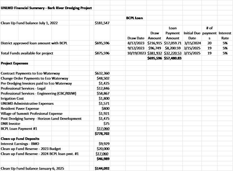
With resident approval the board obtained a 20-year loan through BCPL in the amount of $695,596 at a rate of 5%. Additionally, the UNLMD had a reserve fund of $181,547. The total funds of $875,596 were to be used to pay for the dredging contract with Eco-Waterways for $632,596 plus engineering fees, legal fees, permitting fees, financing payments, and carrying an adequate contingency for the project.
The district received 4 change orders from Eco-Waterways. The change orders resulted from:
The district, as laid out below, made 3 draws on the loan in the Summer/Fall of 2023. Our first payment to BCPL was made in March of 2024. As we near conclusion of the project, we are expecting to have approximately $135,000 remaining in the clean-up fund.
At the UNLMD Board Meeting on January 8th, 2025 the board approved to make a prepayment on our loan with BCPL in the amount of $100,000. This will result in interest expense savings over the term of the loan. Once we receive a new loan amortization statement we will communicate the interest expense savings to residents. Once this prepayment is made, we will have an approximate balance of $35,000 in the clean-up fund for unexpected expenses as we conclude the project. It is our current expectations that we will be able to make one more prepayment on the loan at a date that is not yet determined.
The information below provides detail on funds available for the project, project expenses and our loan with BCPL prior to our prepayment.
The UNL Dredging Project has been idol for the past few months as the geobags dewater and the ground firms up due to cold weather. The Contractor has informed the Board that they intend to begin the operations of the removal of the sediment material the week of January 22 and will continue through March. There will be significant dump truck traffic on Venice Park Road and Mill Road, Monday through Saturday, during this seasonal removal operation. Questions or concerns can be emailed to jjrwood@aol.com and danmac@wi.rr.com.
After a physical review on November 8, 2023 of the river and bay inlet by Todd Weik and Dan McCormack, the dredging part of our project has come to an end. Based on this review yesterday with the measurements taken, it is Todd's opinion that the project limits have satisfactorily been completed.
The depths ranged from 2.75 to 3.00 feet of water depth in the bay upstream to the island. The river section is nearly dredged to the substrate wherever possible. Keep in mind the dredge worked to 5 feet of the shoreline or obstructions where possible. The dredge was unable to work through some of the cattail areas and where there was a "false bottom" which is sediment covered by sand and gravel.
A depth survey using previous GPS coordinates will be provided to confirm these results and the accuracy of the amount of silt removed. To date, Eco Waterways estimates that they removed slightly over the 11,000 cubic yards which was projected for the project.
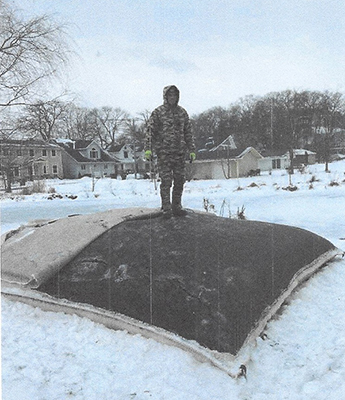
Once the sediment has been dewatered, the bags will be opened this winter to transport to the disposal site. In the Spring of 2024, areas where the bags and equipment were stored, will be restored. I would like to thank all the property owners that allowed us to dewater the sediment on their properties.
This is the largest project that UNLMD has done and I am pleased with the results so far with the dredged areas. The UNLMD board members worked very hard this summer and fall to make certain that the project goals were met. The bay/river is navigable with very little sediment being stirred up by passing motors and much wider for navigation. Areas dredged will be safer for kayakers, paddle boards and swimmers with a depth that will keep them from get stuck in the muck. The environmental impact will be noted with less siltation around the lake. Neighbors adjacent to the project are seeing more fish in these areas which is very encouraging.
If you have any questions please reach out to myself or a board member. Thank you everyone for your cooperation and support.
Sincerely, Jennifer
Jennifer Reek, UNLMD President
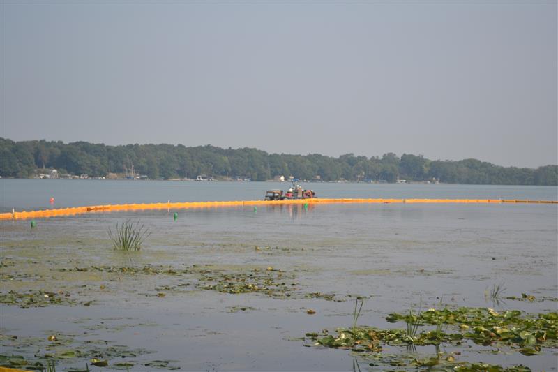
Contractor completed dredging in the North half of the Bay and spent the week of 9/4 moving turbidity curtains to the main channel area. Another dredge was added to the operation to increase productivity. The center line of the channel will get close to 4 feet in depth and about 25 feet across.
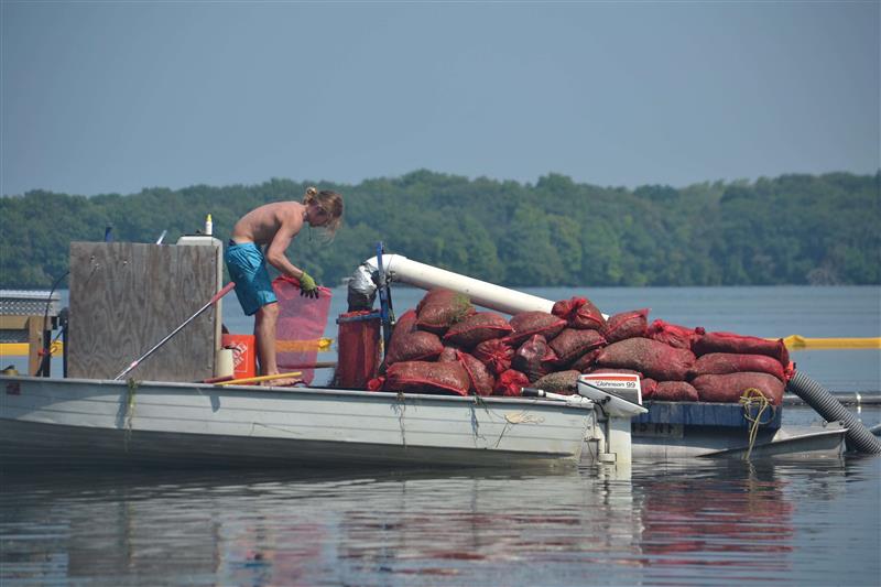
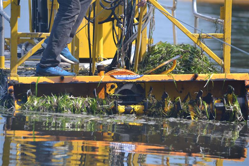
Dredging the bay area kicked off in August 2023. Dredging is the meticulous removal of accumulated sediment. It is essential to rejuvenate the lake's depth, water quality, and overall health. We aim to mitigate silt buildup, enhance aquatic habitats, and ensure a sustainable environment for the community. The video below was shot on three different days and shows the dredging equipment and weeding machine at work.
Owner Upper Nemahbin Lake Management District
Project Name Upper Nemahbin Lake Dredging Project
Location Village of Summit, Waukesha County, WI
Project Engineer Todd Weik, KBJW
Click here to see the Preconstruction Meeting Agenda
ATTN: Todd Weik
Koontz Bryant Jhonson Williams, Inc.
W336 N6978 Stonefield Court
Oconomowoc, WI 53066
Overall Scope of Work Plan
Eco Watery Services is engaged to hydraulically dredge approximately 11,000 insitu cubic yards of material from Upper Nemahbin Lake and Bark River as per the spec plans provided and as described in the Summary of Work and construction documents of the Contract. Material will be pumped into Geo textile tubes at designated laydown site(s), with the carriage return water returning back to the dredged area. This plan is based on information and requirements as provided in the request for bid documents provided by Koontz Bryant Johnson Williams, Inc. Eco Waterway Services (ECO) has also received copies of project permits and this plan is based on compliance with those permit requirements.
Click here to see the UNLD Dreding Work Plan
Click here to see the Construction Site Inspection Report
Click here to see the Elevation Survey of Sediment Bag Properties
Click here to see the Eco Waterway Services Safety Plan
We would like to thank all of the UNLMD residents for attending our Special Meeting on June 7th, 2023. Your public comments and questions were appreciated by the board. The borrowing resolution in the amount of $695,596 passed. 89 residents voted Yes and 52 residents voted No.
We will continue to keep you updated regarding the dredging project on this Website as important milestones for the project are completed.
Sincerely,
UNLMD Board Members
Click Here to download Pdf On Dredging Project Special Meeting June 7th 7:00 pm.
Dear Residents of the Upper Nemahbin Lake Management District,
The UNLMD board is providing an announcement, with the enclosed notice and agenda, of a special meeting being held on June 7th, 2023, at the Summit Village Hall, 7:00 pm. A recap presentation of the dredging project, bid results and next steps for the project will be discussed by the Board. Following the presentation, a vote will take place to authorize the UNMLD to borrow funds related to the Upper Nemahbin Lake dredging project.
In 2011 the residents of UNLMD tasked the board with the objective of addressing the sediment that was released from the Roller Mill Dam due to the Wisconsin Department of Natural Resources (WDNR) order to remove all dam stop logs in the Summer of 2008. The sediment continues to travel throughout the lake and has caused significant issues in the middle bark river and the Southeastern Bay of the lake. A 2009 study completed by the Southeastern Wisconsin Regional Planning Commission (SWRPC), titled “A lake protection plan for Upper Nemahbin Lake” determined a significant increase in sediment depth from 2007 to 2008 due to the abandonment of the dam. The study further identifies the increase in sediment represents a significant loss of habitat for fish and other aquatic organisms.
Since 2011 the board has worked very hard to meet the residents request for a solution to remove the sediment. Facing numerous regulatory challenges from the WDNR and the surrounding land situated in a flood plain, many roadblocks were encountered by the board. In 2018 UNLMD went out for bids to mechanically dredge but faced bids that were more than $1,000,000. The project was tabled in search of a better option. Hydraulic dredging was determined to be the better option but figuring out the logistics due to the floodplain and lack of access to laydown areas were creating new issues for project. Hydraulic dredging is deemed to be a more economical process than mechanical, but you need an area that the sediment can be pumped to and dewatered. That area must be close to the body of water you are working in to make it the more economical option.
In 2020, the Board investigated the use of the Island located in the Bark River, however, the DNR would not allow the sediment to remain on the island which resulted in significant cost increases. Then in 2021 the residents of UNMLD offered a solution at a Board meeting. Residents would allow access on their private land for the needed laydown areas to dewater removed sediment. With this potential solution, the Board spent the last 18 months working with the WDNR to revise our permits from mechanical to hydraulic dredging, update the 250-page project manual, obtain a solid waste permit, obtain a temporary limited easements from property owners, negotiate an easement with the Village of Summit for disposal of sediment, conduct a site visit with all interested contractors and finally publicly advertise the bids to potential contractors.
The board is happy to announce that, despite cost increases over the last few years, the change from mechanical to hydraulic dredging has provided the residents of the district with a more economical solution to the clean-up effort. As of May 18th, 2023, we received back three qualified bids from hydraulic dredging contractors. The three bids were $632,360, $759,000, and $1,312,870. Per Wisconsin state statutes the Board is obligated to take the lowest qualified bid.
Through guidance from the Board’s engineer, there will be a ten (10) percent contingency factor added to the lowest qualified bid. Resulting in a total potential project cost of $695,596. This project cost will be funded through a 20-year loan from the Board of Commissioners of Public Lands (BCPL) a State of Wisconsin program. This commission specializes in loans of this nature and provides attractive terms. Additionally, the Board still has approximately $175,000 in the clean up fund, which monies will be used for such current and ongoing soft costs like legal, engineering, and permitting fees. The Board does not expect these soft costs to be more than $40,000. Therefore, the Board is hopeful to have monies left over after the project is completed that can go to paying down a portion of the loan.
If the dredging project is approved, the payments on the BCPL loan will be paid by an increase of the tax levy to each resident of the UNMLD. Please see the Dredging Project FAQ section on the Lake District website for more detailed information in regard to the tax levy. Using the tax levy is the same method used to fund the annual budget each year and was advised by legal counsel, the BCPL and other Lake Districts for payment of the loan.
Based on the feedback we have received from our residents, civil engineer, contractors, WDNR, SEWPC Study and attorney, the board supports this project. We look forward to everyone attending the lake meeting on June 7th for a recap of the project, next steps and the vote. In the meantime, encourage all residents to visit the Lake District website at http://www.uppernemahbinlake.com/DredgingProject for more information about the project. As well, feel free to email me at jjrwood@aol.com with any questions or comments.
Sincerely,
Jennifer Reek and the UNLMD Board
Click Here to download Pdf Dredging Project FAQ's
This document has been prepared to address questions that Homeowners around Upper Nemahbin Lake may have concerning the proposed Dredging Project for the Southeast area of the Lake and a portion of the Bark River (See Attached Exhibit A and A-1). UNMLD has been working on this proposed dredging project for several years. In 2017 the district completed a 250-page project manual which was submitted to mechanical dredging contractors in order to bid on the project with the intent to complete the project in the Summer of 2018. However, the district elected to reject all the bids and postpone the project due to the wide discrepancy of proposed costs among the three bids. The board has learned a great deal from the process of putting together the 2017 project manual and bids. Since then, the Board has shifted directions away from the cumbersome and costly mechanical process to a more efficient and economical option of hydraulic dredging. This option still presents many challenges but through the Boards extensive discussions with the DNR, Civil Engineers, the Municipality and Lake Owners we feel we have the best possible path forward to complete the proposed project.
This document provides updated questions and answers to the status of the proposed project. Please feel free to reach out to your lake board representatives for any additional questions.
In general, dredged material is sediment that has been removed with an underwater excavating machine called a dredge, which may be conducted either mechanically or hydraulically.
The UNL Dredging Project will use a hydraulic dredging operation.
Has the sediment material been tested for hazardous waste materials?
Yes, the material has been tested per WDNR protocols and has been determined to contain Arsenic but at levels that allow for disposal through regular methods. No other toxic or hazardous substances have been identified. Additionally, sediment samples were analyzed by the UW Extension from an agricultural perspective. The levels of Arsenic in the tested sediment is at a level that is safe to be mixed into existing agricultural fields for cropping purposes. A copy of the testing data is available from our consultant at toddweik@cbceng.com.How is polymer being used, and will it affect the lake?
The Polymer is used to bind the sediment together in the geo textile bag and to ensure that any contaminates like PAH's, Arsenic, Metals, etc. are not released into the carriage return water that flows back into the lake. Under the DNR rules, once you take lake water out, you are responsible for making sure that lake water is returned to the lake in a clean, clear state and that is meets the WPDES specific water clarity requirements. The Polymer we use has been previously approved for use by the WDNR as safe and not a hazard to the lake water or community. The polymer is a binding agent for the solids and used to keep any contaminates in the tubes and should not affect the carriage return water. The water returning to the lake is tested per the WDNR WPDES permit requirements on a weekly basis for the first 4 weeks and then 1 time per month after that.
_______________________________________________________________________________________________________________________________________________________________________________________________________________________________________________________________________
The waterbody’s affected by the proposed project include the Upper Nemahbin Lake and the Middle Bark River.
Approximately 11,000 cubic yards of sediment material, 9,000 cubic yards from the lake and 2,000 cubic yards from the river, is proposed to be removed from the project area.
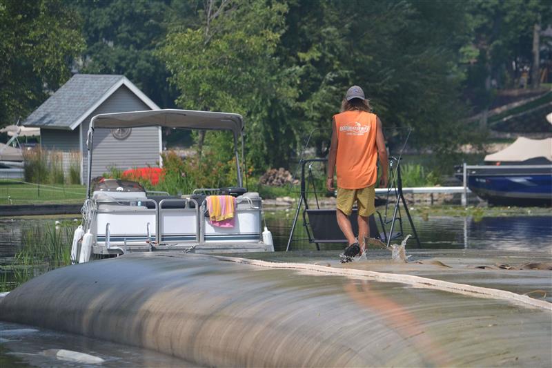
It is intended to utilize a hydraulic dredging operation to capture the sediment and then pump the material to a temporary dewatering site. Once dewatered, the sediment will be removed and deposited at the Village of Summit Park.
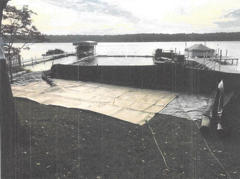
Due to lake access constraints, hydraulic operations will need to be set up on a barge (floating platform) equipped with an anchoring system. The dewatering will be accomplished on private lands adjacent to the project site. The sediment will be pumped into geotubes that will capture the solids and allow the water to exfiltrate through the pores of the geotextile fabric. It is anticipated that the dewatering operation will take approximately 2 to 3 months. Removal of the material to the final disposal site maybe accomplished in the late fall and winter months with the final site restorations completed in the spring. Completing the sediment removal operation in the late fall and winter will reduce the impacts to private property and the Village roads.
Best management practices will include the installation of silt curtains, truck tire tracking pads at the transfer locations and the deployment of temporary sediment barriers that may include silt fence and sediment logs, to prevent sediment from reentering the lake or adjacent lands.
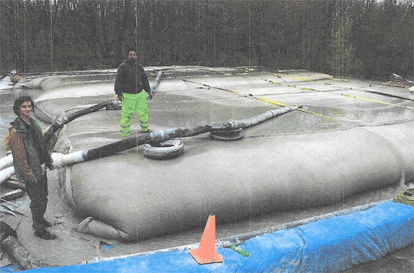
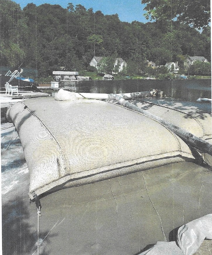
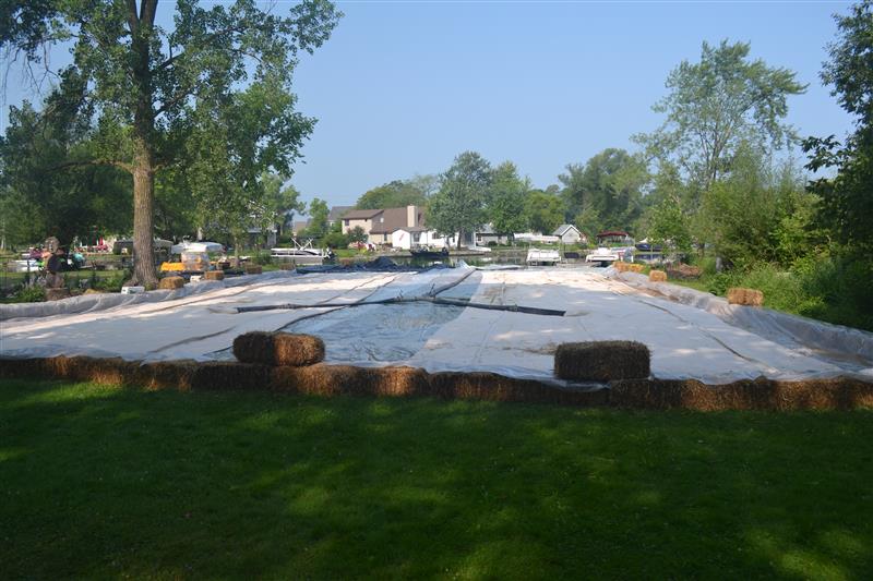
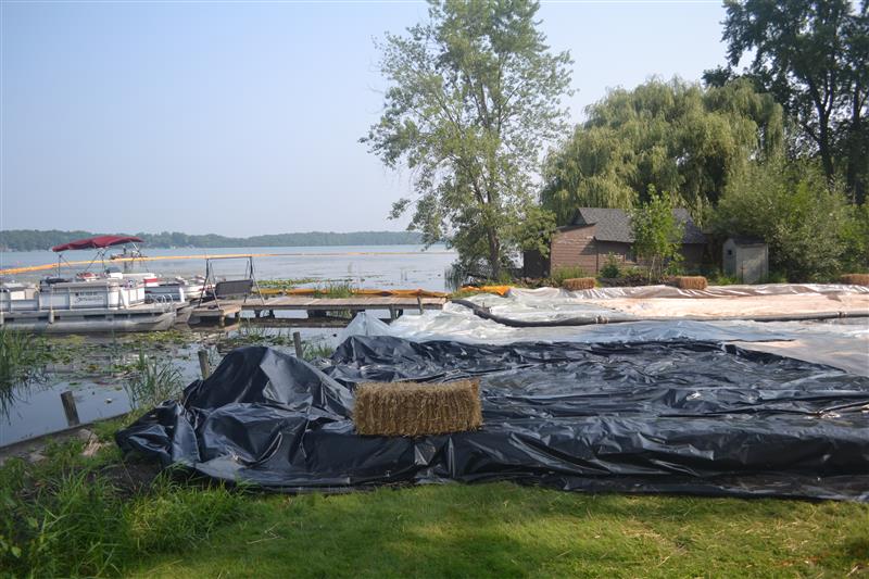
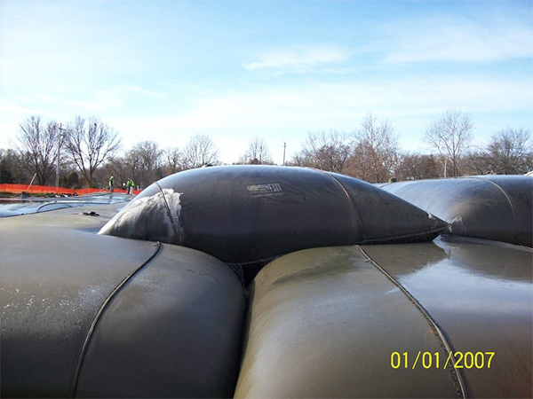
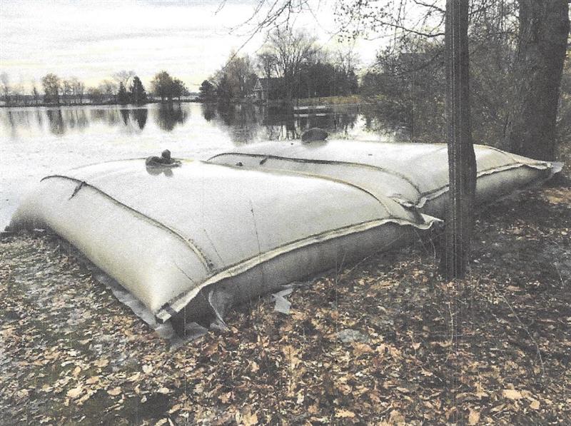
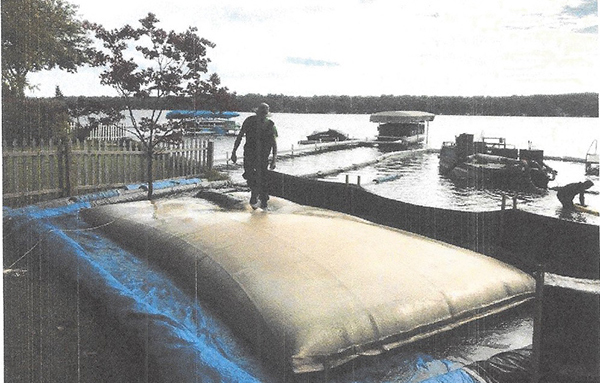
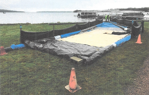
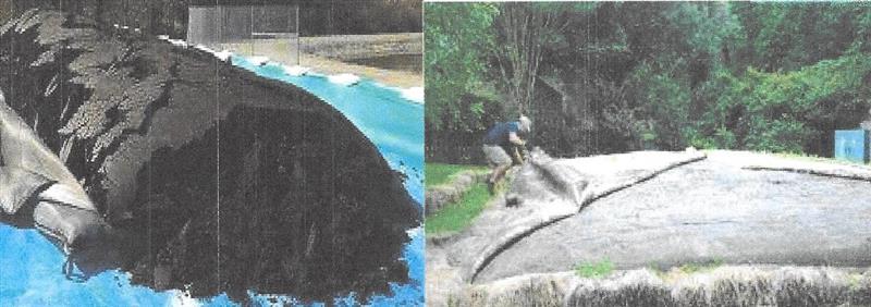
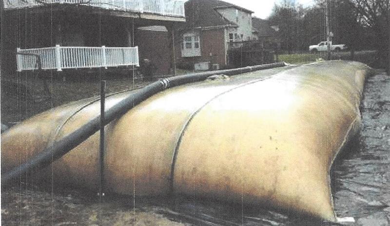
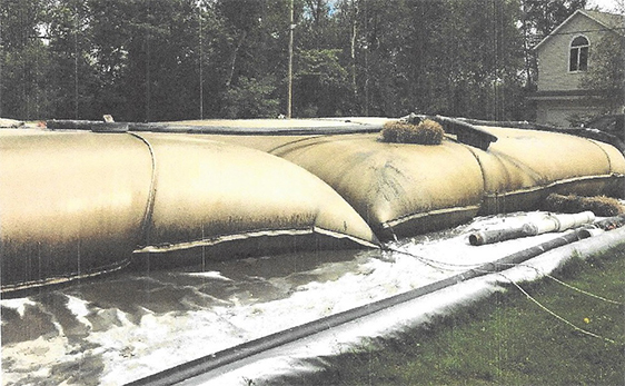
The hydraulic dredging operation will pump the sediment into geosynthetic semipermeable tubes. An example of a deployment of this technology is presented in Figure A. The sediment that is pumped into the geotubes will be allowed to fully dewater. Once the dewatering process is complete, in approximately two to three months, the geotubes will be opened and the sediment will be excavated, loaded into dump trucks, and transferred to the Genesee Lake Road Village Park, 37505 Genesee Lake Rd, Village of Summit, Wisconsin. Sediment logs will be deployed during this process to ensure that the exposed sediment will not be redeposited into the lake or river. The material will be dumped, spread, and tilled into the undeveloped, agricultural field of the parkland. The site is approximately 20 acres in size and the topography ranges from approximately 0.5 to 1.0 percent. The NRCS soil survey indicates that the soils are permeable. A silt fence may be installed, along the perimeter of the field, at the request of the Village Engineer, if the weather conditions and timing of the construction demand sediment control measures. A Temporary Limited Easement will be executed and in place prior to the commencement of the construction activity between the Upper Nemahbin Lake Management District and the Village of Summit that will allow access and use of the land for a disposal facility.
As the material will be considered a solid waste, land spreading of the material will be regulated under Wisconsin Administrative Code NR 518.
Figure A
Sediment Sampling:
Sediment sampling was completed, based upon discussions with the Wisconsin Department of Natural Resources, by Endpoint Solutions in October of 2014. Three sediment samples were taken, based upon directives from the Wisconsin Department of Natural Resources, and analytics were completed based upon Wisconsin Administrative Code NR 347.
An additional grab sample of the sediment material was obtained by Upper Nemahbin Management District staff and provided to the University Wisconsin Extension for soil analysis.
Project Area and Sediment Depths:
The proposed project area includes the southeastern bay of Upper Nemahbin Lake and the Middle Bark River. Existing sediment depths in the bay area were determined and recorded by Endpoint Solutions in March of 2014. The Upper Nemahbin Lake Management District wishes to remove sediment in the bay area to a depth of 3 feet. Cross sections were established on a 50-foot basis and existing and proposed cross sections were developed.
Previous Permitting:
This project was previously issued a Dredging Permit, to mechanically dredge the lake and Bark River, from the Wisconsin Department of Natural Resources, IP-SE-2017-68-00424 and Amended on March 18, 2018.
Anticipated Schedule:
The anticipated start date for the project is July 1, 2023, and completion by March 1, 2024. Dredging operations would be completed between July 1,2023 and October15,2023.
Eco Waterway Services is providing information regarding proposed laydown areas and geo textile tube sizes to accommodate approximately 4800 cubic yards of semi-dewatered sediment material. The Upper Nemahbin Lake Dredging Project consists of the hydraulic dredging removal of approximately 8000 cubic yards of material along the river and the outflow of the river flowing into Upper Nemahbin Lake. We are using the calculation of 60% of insitu sediment removal quantity to determine geo textile tube capacity limits. (8000 x 60% = 4800CY). Information will be provided by riparian address of proposed laydown area. A site map of each of the proposed areas will be included in this information report.
Area 1
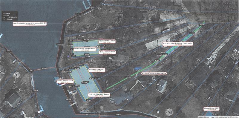
Area 1 - 2975 Cubic Yards
34233 Venice Park Road - Susan Fisher - 1100 Cubic Yards - laydown area proposed to accommodate (2) 45 circumference X100 length geo tubes in a laydown area of approximately 60 ft x 100 ft. Each of these tubes should accommodate 350 cubic yards. Once filled, (1) 60 circumference x 80 geo tube will be stacked on top that will accommodate an additional 400 cubic yards.
34235 & 34236 Venice Park Road - John Sommer and Derrick Bay - 1750 Cubic Yards - laydown area proposed to accommodate (2) 60 circumference x 110 length geo tubes in a laydown area of approximately 80 ft x 120 ft. Each of these tubes should accomodate an additional 650 cubic yards.
Access and sediment disposal path to laydown area will be on the east end of 34236 Venice Park Road as shown on map.
Extra laydown area - an extra area in one of the driveways located at 24236 Venice Park Road could be used for an additional laydown area to accommodate (1) 22 circumference x 110 length geo tube that would accommodate 125 cubic yards
Area 2
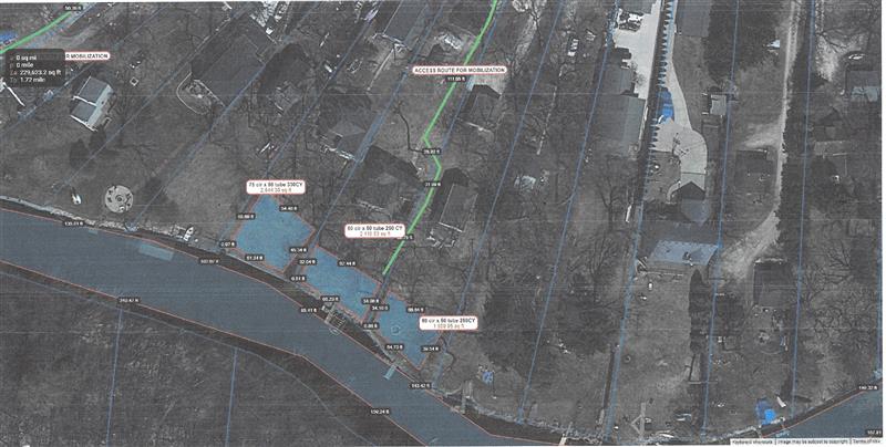
Area 2 - 830 Cubic Yards
34201 Venice Park Road - Jeffery Bourdo - 330 Cubic Yards - laydown area proposed to accommodate (1) 75 circumference x 50 length geo tubes in a laydown area of approximately 50 ft x 60 ft.
34149 Venice Park Road - John Meier - 250 Cubic Yards - laydown area proposed to accommodate (1) 60 circumference x 50 length geo tubes in laydown area of appoximately 40 ft x 60 ft.
34143 Venice Park Road - Robert Speer - 250 Cubic Yards - laydown area proposed to accommodate (1) 60 circumference x 50 length geo tubes in laydown area of approximately 40 ft x 60 ft.
Access and sediment disposal path to laydown area will be on the east end of 34149 Venice Park Road as shown on map.
Area 3
Area 3 - 1150 Cubic Yards
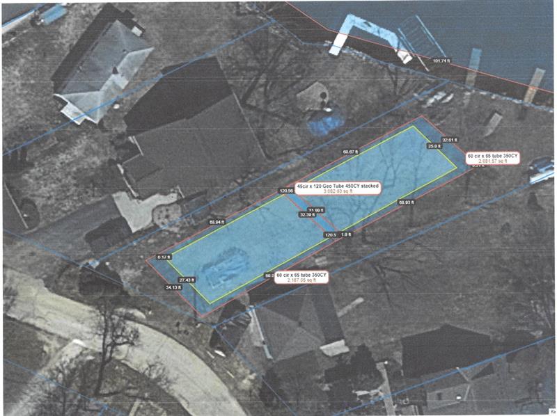
SUMT0669035 Lot Venice Beach Road - Tom Olesom - 1150 Cubic Yards - laydown area proposed to accommodate (2) 60 circumference x 65 length geo tubes in a laydown area of approximately 40 ft x 140 ft. Each of these tubes should accommodate 350 cubic yards. Once filled, (1) 45 cirumference x 120 geo tube will bbe stacked on top that will accommodate an additional 450 cubic yards.
Access and sediment disposal path to laydown area will be from Venice Beach Road.
Smaller Bags - 22 and 30 circumference
 |
 |
 |
 |
Larger tubes 60 or 75 circumference
 |
 |